![]()
Map of the northern part of Borneo (Sabah, Sarawak, East-Kalimantan) - print version of this map
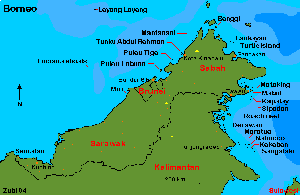
Click on map / names to get to a description of dive areas. Westcoast of Sabah and Sarawak - Lankayan area - Sipadan-Mabul - Sangalaki-Derawan
You can find detailed information about dive operators, liveaboard operators, dive safety, dive conditions, climate, hotels and how to get to Borneo / Kalimantan on a separate page ready to print.
![]()
Sipadan-Mabul: Probably the best known dive areas are the islands of Sipadan, Mabul and Kapalay in the northwest of Borneo. I've dived there several times and was always impressed by the huge variety of animals seen there, the diving here is world-class! Around Sipadan the reef drops down spectacularly, huge schools of barracudas, mackerels are seen on nearly every dive, turtles and large sharks abound. Only half an hour by boat from Sipadan are the islands of Mabul and Kapalay. Dive sites here are shallow, but this is an excellent place for so called muck diving! I found several species of frogfishes, a variety of nudibranchs, shrimps, sea horses, special fishes like mandarin fishes, scorpionfishes etc. A great place for macro photography.
Westcoast of Sabah and Sarawak: Another premier dive destination is Layang Layang (Terumbu Layang Layang), a small island, only 2 kilometer long, lying in the south China sea in the east of Borneo. Since the ocean floor drops to an amazing 2000 metres from the edge of the atoll, this is a great place for large pelagic fish such as gray reef sharks, white-tip reef sharks, hammerheads as well as large schools of barracudas and mackerels and many turtles. This is quite a exclusive dive resort and can only be reached by small airplane from Kota Kinabalu (300 km). All the dive sites are around the atoll, since there are no other islands in the vicinity. Layang Layang is open only between February and the end of October.
Around Kota Kinabalu are several dive areas, but they are not as spectacular as other dive areas such as Layang Layang. There is a large marine park, Tunku Abdul Rahman, which can be reached from the city. Further down the west coast and about 8 km off the Brunei bay lies Labuan island. Reefs here are not very good, but south of Labuan island are four large wrecks, and on the island you will find more information in the World War II Memorial. Visibility is not so good since there are several rivers in the vicinity.
About scuba diving around Brunei little is known, but further south in Sarawak are some interesting but not very well known areas such as Miri and the Luconia Shoals. The Luconia shoals (divided in South and North Luconia Shoals) lie off the North-Western coast of Sarawak over an area of several hundred kilometres in the South China Sea. You can only reach it by liveaboard vessel.
Near the border to Kalimantan, near Kuching there is also some
diving possible around Sematan.
Lankayan area: Lankayan Island, lying in the north, close to Sandakan, is a small island with a large choice of dive sites just close by. Most dives are in shallow water and with low visibility, but during March to May whale sharks migrate through the Sulu sea and may visit that area. The island is a great place to relax. Relatively close by is Turtle Island (Pulau Selingan), a turtle sanctuary and hatchery.
![]()
Sangalaki-Derawan: Some very exciting diving can be found around several islands and atolls lying just to the east of Tanjungredeb (Berau) in the strait of Makassar: Derawan, Nabucco, Kakaban, Maratua and Sangalaki.
Sangalaki (also written Sangalakki) is known for the large gatherings of manta rays that come here. The reef is actually not so nice, but you don't look at it, when these huge animals swim by! About 15 min by boat is another dive site, Samama which is good for macro. Maratua (also written Merah Tua) has several impressive drop-offs and you will have a good chance to sea large pelagics like sharks, tuna, eagle rays and schools of barracuda, trevally and mackerel. Derawan and Nabucco are known for the critters such as frogfishes, shrimps, scorpionfishes, ghostpipefishes and invertebrates like nudibranchs and special shrimps. Probably the most special place is Kakaban, a most unique experience! In the middle of this island is a mangrove fringed lake where thousands of non-stinging jellyfish live. This place is similar to jellyfish-lake in Palau. Around the outer reef there are drop-offs for drift-diving. Visibility can sometimes be low due to silt from the river in Tanjung Redeb.
Information |
Dive sites around the Daymaniyat Islands, Kharabah, Fahal in Oman (maps, descriptions) - print version |
Photos |
Information |
Galapagos islands: center Galapagos, north Galapagos, southeast Galapagos, west Galapagos |
| Photos |
| Tauchplätze | Indonesien allgemein - Bali - Bali Nord - Bali Ost - Bali Süd - Bunaken - Bangka - Manado- Lembeh |
| Informations-Seiten | |
| Druckversion Karten | Indonesien (Strömungen und Wallace Linie) - Klima-Karte Indonesien - Bali Tauchplätze - Lembeh Tauchplätze - Bunaken und Manado Tauchplätze - Karte der Tauchplätze in den Galapagos - Druckversion |
| Druckversion Texte | Indonesien allgemein - Bali Nord - Bali Ost - Bali Süd - Bunaken - Bangka - Manado - Lembeh |
| Spezielle Themen | Grundsätze zur Berichterstattung über Tauchgebiete |
. Copyright Teresa Zubi (write to
me)