![]()
|
Dive areas around Palawan are very rich and varied. In the north of Palawan you will find a beautiful landscape around El Nido. Even further north, between the northern islands of Busuanga and Culion in Coron Bay lies an outstanding wreckdiving area (look at the separate report about wreck diving in Sangat). Out in the Sulu Sea are several small islands and atolls (for example the Tubbataha reefs) that can only be reached by liveaboard vessels but which offer excellent wall dives, sharks, mantas and lots of fish. For us divers Palawan is truly worth a longer visit! On this page: Tubbataha reefs - Palawan mainland - Cuyo islands - Apo reef (Mindoro) |
 |
![]()
The Tubbataha Reefs were declared a National Marine Park in 1988 and a UNESCO World Heritage Site in 1993. The park is the home of numerous marine species. Most divers visit this area because of the chance to see large pelagics such as sharks, mantas, rays, turtles, mackerels, tunas and barracudas but we also saw interesting smaller animals such as nudibranchs, special crabs and shrimps and corals. The reef is very rich in fish, large schools of different species practically covering the corals and visibility at some days is just unbelievably good.
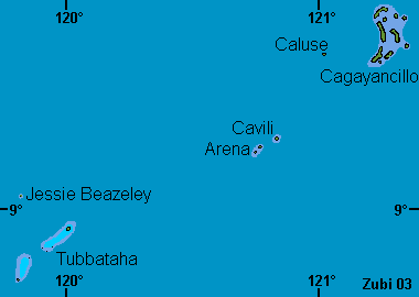
The Tubbataha atolls lie 182 km southeast of Puerto Princesa and are part of a larger group of tiny islands that stretch from the northeast to the southwest, compromising Cagayancillo, Caluse, Cavili, Arena, then the Tubbataha reefs, Bastera (Maeander Reef), Bancoran, San Miguel islands and Cagayan close to Borneo. However these islandsdon't belong to the National park and thus are not protected. Actually I heard there is quite a lot of fishing going on in the south, even with factory ships.
![]()
The Tubbataha Reefs can only be reached by liveaboard boats and only from the end of March to June. The ships must use the moorings or cruise and may not anchor in the park area. If the weather is bad with a lot of wind and high waves it is nearly impossible to moor around the Tubbataha reefs, because there is no shelter what so ever! Some liveaboard ships are quite small and it can become very rocky if the waves start!
All these reefs consist of vertical walls or very steep slopes and are rising from great depths. You must expect strong currents that might change directions so most dives are drift dives. I advise to bring a dive computer and a safety sausage or another signal device. Night dives are only possible if there is no current. Check before starting your dive and discuss who will pick you up, if a current springs up during the night dive.
Want to know more about how to assess accurately the rate of current? Click here
![]()
![]()
The Tubbataha reefs consist of two atoll-like reefs each with an inner lagoon and are separated by a 7km wide channel. On the larger atoll there is a small island, more like a sandbank. Bird island as it is called used to be only sand. Now covered with some trees supposedly planted by a dive operator, there are not that many birds anymore. This sand cay is also used as a nesting ground by marine turtles. More maps on the website of the Tubbataha Reef National Marine Park.

Tubbataha Reef North Atoll: 1. Bird
island / 2. Ranger Station / 3. Malayan
Wreck / 4. Amos Rock (Southwest Rock) / 5. South
Rock
Tubbataha Reef South Atoll: 6. Black
Rock / 7. Lighthouse islet / 8. Jessie
Beazeley Reef
Red dots are the moorings for the liveaboard ships. The light blue areas are
lagoons, darker blue areas reefs.
![]()
Bird island (Tubbataha
north face): this is a steep wall with overhangs, swim throughs and crevices.
Some areas have sand trickling down from above like a waterfall and there is
a corner where you feel strong currents coming from both sides. The reef top
is quite nice with lots of hard coral heads and sandy areas in-between. There
are always several sharks resting on the sandy area. One of them was lying there
so quietly getting cleaned by its Remora fish, that the garden eels around it
were coming out of their holes! On one dive we also encountered a giant reef
ray, easily about 2 meter across, who was resting on a ledge and took off, when
we approached.
![]()
Ranger Station: There is a
channel going to the ranger station. Actually we didn't dive there, so I can't
give any details.
![]()
Malayan Wreck: You can see
the remains of a Malayian ship that stranded here from the mooring place. We
stayed here for a couple dives and enjoyed it immensely. During one dive we
had a lot of current on one of the corners and lots of fish hanging around there,
a large group of dogtooth tuna and even an eagle ray. Afterwards on the reef
top we saw some moray eels, angelfishes, butterflyfishes and other smaller reef
fish as well as some lobsters, starfish and flatworms.
![]()
Amos Rock (Southwest Rock):
I liked this dive site a lot. The wall is wonderfully covered with huge gorgonian
fans and whip corals and if there is some current this place is just chock a
block with large fish! We saw so many sharks I gave up on counting, mostly white
tip reef sharks and gray reef sharks. There were plenty of mackerels, snappers,
some large groupers, several Napoleons, some of them real granddaddies and all
of them moving in the current - a wild ride!
Around this area we also had a very interesting night
dive. We checked the current, but towards the end of the dive we had
to dive back to the ship against the current. This was one of the best night
dives in this area. We found a lot of nudibranchs, some like the huge Pleurobranchus
forskali (ca. 30cm!) or the rare Atagema (Trippa) intecta. On a so called broccoli
coral I found a small pink crab, Hoplophy oatesii, that is perfectly camouflaged.
There were a lot of lobsters, large crabs to be seen. Twice we saw the shy twinspot
lionfish.
![]()
South Rock: Steep wall with
a lot of gorgonian fans, some overhangs. We encountered a large group of tunas
and longface emperors. On the sandy areas there are always a lot of sea cucumbers
like the special looking Thelenota ananas. As during nearly every other dive
we saw several turtles, some of them not shy at all, so we could watch them
from close up.
Black Rock:
Steep wall not covered with much corals. In-between sandy channels coming from
the reef top. There were some sharks patrolling, mostly white tip reef sharks
and a few Napoleon wrasses. At the very end of the dive we encountered a manta
ray on the reef top. It stayed around us for quite a while - that made my day!
![]()
Lighthouse islet: Steep
wall and a large reef top area. Hard and soft corals, anemones with anemone
fishes, lots of anthias.
The name of this reef is also written as Jezzly Beazley on some
maps. This reef lies about 23 km northwest of the Tubbataha reefs but is not
protected as a Marine Park, so fishing is allowed here. The reef here is so
small, you probably have visited it in two dives. This place is not sheltered
at all, so the dive operators will only stop there, if the weather is calm.
The reef is covered with corals and gorgonians and large schools of fish. The
southern part of the reef has an extensive reef top. Currents can be strong.
Arena island, 89 km northeast of the Tubbataha reefs and Cavili
close by are small coral islets and sand cays with fringing reefs. Arena has
a lighthouse and seaweed farms. Further north lie Caluse and Cagayancillo, both
surrounded by reefs. This whole area is not so nice to dive, since there has
been a lot of dynamite fishing and large parts of the reefs are destroyed.
Bastera (Maeander Reef) is a sand cay 93 km southwest of Tubbataha south island.
The wreck of the Oceanic lies on the east side. Bancoran island, a further 60
km southwest of Bastera, is densely wooded and inhabited. I haven't visited
any of these islands!
![]()
Diving: I didn't dive when staying on the mainland but I heard there is some nice diving in Honda Bay (Dos Palmas), Fondeado island near Castillo point, the Panglima reef near Pasco point and Table head reef which lies south of Puerto Princesa. In the north of Palawan you can also dive in El Nido and Port Barton. Look at this page with dive information.

Land trip: Instead of diving we
made a trip from Puerto Princesa to the underground river
in Sabang. The resort we stayed in Puerto (Casa Linda, a very nice and
quiet place) organized an aircon van for us and after driving through clouds
of dust stirred up by the bus in front of us I was glad we didn't go by public
transport! The trip over the small mountains, along the coast and over some
hills with beautiful limestone formations was very enjoyable.
The underground river, also called St. Paul Cave, is a very large tunnel like
cave and lies inside the St. Paul Subterranean National Park. To get there you
either walk (shorter walk ca. 1 to 1 1/2 hours, jungle walk about 2 hours) or
take a small banka boat. There is a nice lagoon in front of the entrance to
the cave. I had my swimming gear along and took a dip. I swam even a little
inside the cave and watched the swallows flying out of the entrance and over
my head. The park rangers didn't like that so much...!
To visit the cave the park rangers will take you in with a boat. They have car
batteries along, so you have strong lights to look at the formations inside
the cave. We made a trip of about 45 minutes and enjoyed it very much, it was
very impressive. Try to go with only a few people on the boat, this place doesn't
need people constant chattering.
Before we turned around to paddle back I asked the ranger, if we could turn
out the lights. That was very special, since inside a mountain you really don't
have any light (not even the stars). As we sat in pitch darkness we started
to really hear the twittering of the bats all around us and the calls of the
swallows that had followed our lights inside the cave, on our skin we felt a
slight wind and our boat was tugged by the current back towards the entrance!
![]()
These islands lie in the northeast of Busunga. There are some resorts with dive operators. For details please look at the websites in the information section.
![]()
Check out this separate page with a lot of information about the world war II wrecks in Coron Bay.
![]()
Apo Reef is an atoll of about 40 square kilometer with a small island in the east. 1996 Apo Reef was declared a Protected Area. Apo Island even has a small mangrove forest and lake at its center. Apo reef is often reached by liveaboards from Busuanga, Palawan, so I added a short description of this great dive site to this page.

Apo reef and Apo island as seen from the air
Diving around Apo reef you have a good chance to see sharks and other pelagic fish and turtles. The reef is famous for its marine life and drop-offs, which are mostly vertical walls down to 30 - 80 meter. Most of the diving is done on the northern wall of Apo reef, where there are quite a lot of currents and gorgonians and other sea fans grow on the wall. There are quite a lot of currents and gorgonians and other sea fans grow on the wall. This place is great for pelagics. On the east, at Shark ridge, there is a good chance to see blacktip and whitetip reef sharks and sometimes even Mantas. On the southeast there is a wall, Binangaan, and around Apo island there are more interesting dive sites. There is also an underwater pinnacle that almost reaches the surface called Hunter's rock which lies about 20 km west of Apo Reef. This is a great place for sea snakes. I heard that during the mating season (June through July) literally thousands of snakes appear here. More to the north there is a small reef, Merope reef.
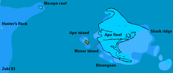
Map of Apo island and Apo Reef (Mindoro). Depths: 5-10m / 10-50m / 50 to 200m / more than 200m (print version)
![]()
Information |
Dive sites around the Daymaniyat Islands, Kharabah, Fahal in Oman (maps, descriptions) - print version |
Photos |
Information |
Galapagos islands: center Galapagos, north Galapagos, southeast Galapagos, west Galapagos |
| Photos |
| Tauchplätze | Indonesien allgemein - Bali - Bali Nord - Bali Ost - Bali Süd - Bunaken - Bangka - Manado- Lembeh |
| Informations-Seiten | |
| Druckversion Karten | Indonesien (Strömungen und Wallace Linie) - Klima-Karte Indonesien - Bali Tauchplätze - Lembeh Tauchplätze - Bunaken und Manado Tauchplätze - Karte der Tauchplätze in den Galapagos - Druckversion |
| Druckversion Texte | Indonesien allgemein - Bali Nord - Bali Ost - Bali Süd - Bunaken - Bangka - Manado - Lembeh |
| Spezielle Themen | Grundsätze zur Berichterstattung über Tauchgebiete |
. Copyright Teresa Zubi (write to
me)