![]()
I have been to Sulawesi countless times and still always find some new animals that I haven't seen before and there are still new dive areas to be discovered. I can really recommend scuba diving in Sulawesi. Dive sites in Sulawesi are very varied - from steep coral walls around Bunaken and Bangka to muck diving in Lembeh. You will find big fish and islands swept by currents around Siau and wrecks in Makassar, untouched atolls in Tukangbesi (Wakatobi) and gentle reefs in Donggala. Many places are not very well explored and only a few dive operators go there, mostly with liveaboards.
![]()
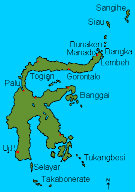
| Bunaken National Marine Park | A well known National Park including five islands, most with very steep walls. Good chance for pelagics like sharks, mackerels and tunas as well as marine turtles. Nice coral walls with small caves and overhangs. |
| Manado Area | Several dive sites close to the city of Manado which are good for muck diving. Rare critters like ghost pipefish, Mandarin fishes and Rhinopias scorpionfishes and a small wreck in the north of Manado. |
| Bangka | Most dive sites are really well covered with colorful soft corals and current swept. Good chance for large schools of fish. |
| Lembeh | The place for muck diving with a selection of the most rare and bizarre: frogfishes, scorpion fishes (Ambon-, Rhinopias, stonefish etc.) dragonets, ghost pipefishes, rare nudibranchs, mimic octopus and wonderpus, pegasus and a lot more. Also 5 wrecks and some nice coral gardens. |
| Siau, Sangihe and Talaud islands | By liveaboard to the volcanic islands in the north. Hear an active volcano under water, dive on a old lava flow and look at the gas bubbles rising from underwater hot springs. |
| Gorontalo | Nice reefs, underwater rock formations and caves. |
| Togian islands | Interesting group of islands with lots of fish, some endemic corals and a large mangrove area. Interesting dives at a volcanic island, plane wreck. |
| Banggai islands | Nice coral reefs and steep walls with pelagics. |
| Donggala (Palu) | A group of small atolls with nice coral cover and some rare animals like frogfishes, ghost pipefishes and stonefishes. |
| Makassar (Udjung Pandang) | Wreck diving pure just outside the city of Makassar. |
| Bira, Selayar and Takabonerate | Steep walls and lots of current but also a lot of sharks, tunas and mackerels. |
| Tukangbesi, Wakatobi | A group of varied islands with some very rare animals like pygmy seahorses, nudibranchs and scorpionfishes. Visit the remote atolls with untouched coral reefs by liveaboard. |
![]()
Map of Sulawesi: click on dive sites
|
Diving around Manado Diving in Lembeh Strait Siau and Sangihe Diving in Central Sulawesi Diving in Southern Sulawesi Diving in Southeast Sulawesi |
![]()
Indonesian refer to their homeland as "Tanah Air Kita" which means "Our earth and water". Sulawesi was formerly called Celebes and lies north of Nusa Tenggara and almost reaches the Philippines in the north. It covers about 189'200 square kilometer and has over 6000 kilometer of coastline ringed with reefs and more than a hundred offshore islands. Perhaps 3000 species of fish alone populate the reefs around Indonesia. It is said that nowhere in Sulawesi you are more than 100 km away from the ocean.
About 40 million years ago the northern Australian tectonic plate crashed into the Asian plate creating Eastern Sulawesi. Eastern Sulawesi then proceeded to move northwards and crashed into Western Sulawesi beginning the fusion between the two around 15 million years ago.
The result are the provinces 17 active volcanoes. Most of them are concentrated in the north of the island (Gorontalo to Manado) and the Sangihe and Siau Islands. Just a few years ago (2001) one of the volcanoes near Manado was spouting fire. Click here for lists of volcanoes in Sulawesi (Directorate of Volcanology, Indonesia / Global Volcanism Program).
On my divetrip to the Siau islands we were anchoring close to Karangetang, Siau's volcano and could observe the red fire and the clouds of smoke. Underwater while diving on black volcanic sand we could hear the explosions from the volcano!
If you visit Sulawesi it is also important to understand, why the animal life here is so different from that of Borneo or the Malaysia mainland. Through the Makassar Strait between Kalimantan (Borneo) and Sulawesi goes the so called Wallace Line (named after the naturalist Alfred Russel Wallace who explored the islands between 1854 and 1862). This is the western boundary of a zone of transition between Asian and Australian fauna. This zone, encapsulating Sulawesi, Nusa Tenggara and Maluku, is called Wallacea. With animals and plants from both regions to draw upon, as well as a huge number of endemic species (= restricted to a particular geographic region and found nowhere else in the world), Wallacea is specially interesting for naturalists and divers alike. Click here for more information about Wallacea.
![]()
![]()
Information |
Dive sites around the Daymaniyat Islands, Kharabah, Fahal in Oman (maps, descriptions) - print version |
Photos |
Information |
Galapagos islands: center Galapagos, north Galapagos, southeast Galapagos, west Galapagos |
| Photos |
| Tauchplätze | Indonesien allgemein - Bali - Bali Nord - Bali Ost - Bali Süd - Bunaken - Bangka - Manado- Lembeh |
| Informations-Seiten | |
| Druckversion Karten | Indonesien (Strömungen und Wallace Linie) - Klima-Karte Indonesien - Bali Tauchplätze - Lembeh Tauchplätze - Bunaken und Manado Tauchplätze - Karte der Tauchplätze in den Galapagos - Druckversion |
| Druckversion Texte | Indonesien allgemein - Bali Nord - Bali Ost - Bali Süd - Bunaken - Bangka - Manado - Lembeh |
| Spezielle Themen | Grundsätze zur Berichterstattung über Tauchgebiete |
. Copyright Teresa Zubi (write to
me)