![]()
 The
Galápagos are an isolated group of volcanic islands that lie in the Pacific
ocean about 960 km west of Ecuador right on the equator. The name has its origin
in the Spanish name galápago for saddle and turtle. They are also called
"Las Islas Encantadas" (enchanted islands) or Archipelago de Colon
(Christopher Columbus archipelago). The Galápagos are an archipelago
with 14 major islands, 6 small islands (under 5 km2) and many islets, rocks
and reefs. The total land mass is about 7'800 km², but the ocean area over
45'000 km².
The
Galápagos are an isolated group of volcanic islands that lie in the Pacific
ocean about 960 km west of Ecuador right on the equator. The name has its origin
in the Spanish name galápago for saddle and turtle. They are also called
"Las Islas Encantadas" (enchanted islands) or Archipelago de Colon
(Christopher Columbus archipelago). The Galápagos are an archipelago
with 14 major islands, 6 small islands (under 5 km2) and many islets, rocks
and reefs. The total land mass is about 7'800 km², but the ocean area over
45'000 km².
The Galápagos islands are volcanic. They are the visible remains of a long-lived mantle hotspot (= a column of rising magma), which has produced a chain of sea mounts known as the Carnegie ridge. The Galápagos plume is thought to lie beneath the western islands of Fernandina and Isabela. The major volcanoes are shield volcanoes which still show a lot of volcanic and seismic activity. Several volcanoes on Isabela are active and in the north just in 1991 the volcano of Marchena was also erupting. Since most of the Galápagos is surrounded by deep ocean, you can only see the very top of the volcanoes, the rest is underwater. The oldest of the islands (Española) is about 3 to 5 million years old, but there are indications, that islands have been present over the Galapagos hotspot since at least 9 million years. The Galapagos islands were never connected to the mainland. The northern islands of Wolf and Darwin are not part of the Galapagos submarine platform, but part of an elongate volcanic ridge, the Wolf-Darwin Lineament. Galapagos Geology on the Web - Global Volcanism Program (Galapagos volcanoes)


Hornitos and Pahoehoe lava from the Sullivan Bay
Please note: The islands have a Spanish as well as an English name. Most of the islands were originally named by English sea captains. I have used the Spanish names in these pages, since the Galápagos islands belong to Ecuador which is Spanish speaking.
![]()
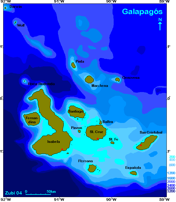
0-200m / 200-400m
/ then 400m-contour intervals to 3200m below sea
level
Click on the names to jump to the dive areas.
![]()
![]()
The diving on the Galapagos islands is - with very few exceptions around Puerto Ayora - only for experienced or intermediate divers. The water generally is cold, there are strong currents, surge and eddies underwater and waves on the surface, the rocks you want to hang on are sharp volcanic tuff and the next recompression chamber is usually far away (see Galapagos dive info).
Any time is a good time to visit Galapagos Archipelago for scuba diving. Although the Galapagos lie right on the equator, the water is quite cold. It is recommended to wear a 5 to 7 mm wetsuit, hood and gloves. Visibility in the Galápagos is between 5 and 25 meters, mostly 12 to 18 meters, so it is not to be compared with conditions on tropical reefs. Visibility tends to drop during the rainy months of February to April. It can be windy and choppy in July to October. Major currents see map further below.
May to December is the cold season and December to May the warm season with sometimes murky water. The northern islands are warmer (up to 26º C), central and southern islands colder (21º to 25º C), west of Isabela very cold (16° to 23°C). There are often thermoclines between 10 to 30 meters depth. During an El Niño phenomenon the water temperatures can rise from 25° to 30°.
Sea-surface temperatures (SST) in the Galapagos - print version
under 20°C - 20 to 21°C - 21 to 22°C - 22 to 23°C - 23 to 24°C - 24 to 25°C - 25 to 26°C - over 26°C |
The Galapagos are desert islands, although they lie on the equator,
so generally it doesn't rain very much. On some islands it only rains on the
side reached by trade winds (for example St. Cruz)
January to March: rainy period and warm season
April to June: can be rainy, the cold season starts
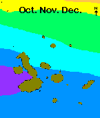
July to November, December: dry period and cold
season, overcast and misty with a foglike rain called garúa.
Either you stay on one of the inhabited islands and make day trips with one of the dive centers operating there, or you make a 7 to 10 day-trip on a dive-liveaboard. Galapagos offers quite a large selection of dive boats and dive operators. However have a close look at the prices on even more important at the itinerary - where do the boats start and how long do they take to the first dive site (St. Cruz and Baltra are closer to most dive areas than for example San Christobal). How many dives a day do they offer, how fast are they (very important if you want to reach islands like Wolf or Darwin). Dive tours on the Galapagos are always on a tight schedule, where and when you dive is planned and specially on liveaboards not much choice is left. We did one dive on one of our trips where we knew there was going to be very bad visibility - we had dived there with another dive operator just the day before - but it was on the itinerary, so we had to dive there...
I recommend you make at least one or two land trips since you are on the Galapagos. A third possibility is to take a ship that is used to make land trips and arrange for one or two dives a day. However I think, this is only for people who like to dive occasionally, since these trips are aimed towards how to visit the best land sites and not the best dive sites!
Night dives were possible until a short time ago - on this trip (2006) we were informed, that they are not allowed anymore.
![]()
In the pages about the Galapagos islands, the word "endemic" is often used to describe a species that only occurs on these islands. Endemic animals or plants are restricted to a particular geographic region and found nowhere else in the world. Endemism usually occurs in areas that are isolated in some way. Since the Galapagos were never connected to the mainland which lies 960km away, all species had to reach the islands either by swimming (fish, sea lions etc.), by flying (birds, insects etc.) or on rafts (land animals, mammals, reptiles etc.). Once here they evolved and occupied different ecological niches. The endemic species in the Galapagos are specially adapted to the harsh conditions on the archipelago like the scarcity of fresh water, the availability of only certain food and the dark volcanic rocks. On the Galapagos endemism is much higer on land than in the water. List of the endemic species of fishes in the Galapagos
Marine life in the Galapagos is very rich, though not so varied as in warmer tropical waters. Due to the cold water there are only a few species of corals and those grow mostly in the subtidal zone. There are so called reefs near Floreana (Devil's Crown, Onslow island), Cousins Rock, Bartolomé Island, Champion island and Wolf and Darwin, but actually they are more like rocks with a sparce cover of corals, sponges and algae.
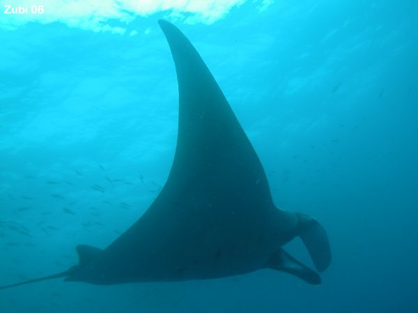
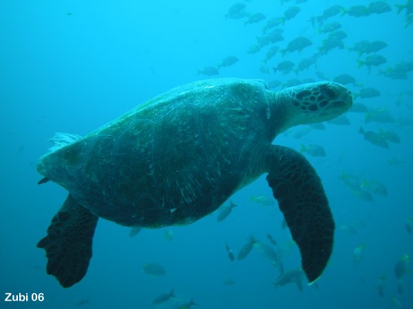
In the warm season (from May to December), the chance to see whale sharks is very high (in the northern islands), and you can also observe them in the central islands. In the cold season (December to May) the chance to see whale sharks is about 50 percent, and you see more rays like mantas, mobula, and eagle rays, since they get together in schools to mate. Hammerheads can be found throughout the Galapagos Archipelago year-round but in the northern islands there are much larger groups found. The large schools of fish, sea turtles, sea lions, iguanas and penguins can be seen during the whole year.
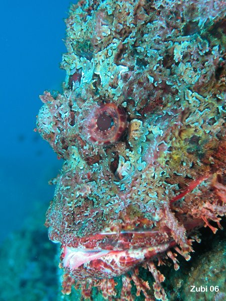
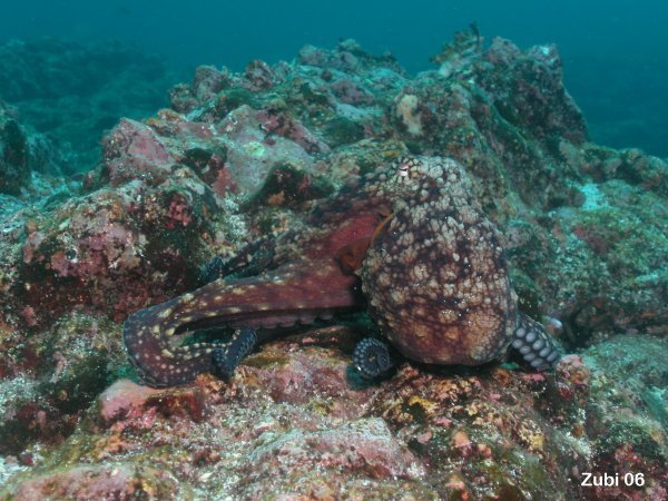
Fishes:Jack Grove and Robert J. Lavenberg have documented 444 fish species in 112 families with 9.2% endemic species (= restricted to a particular geographic region and found nowhere else in the world). From the 41 endemic species, most are blennies and stargazers (11 species Blennioidei) and small fishes of the family Percoidei like grunts and drums (10 species) and brotulas (6 species Ophidiformes) and a few gobies and eels. The endemic fishes are mostly small fish, that live close to the shore. List of species of fishes in the Galapagos (endemic and others) / Photos taken in the Galapagos Since the Galapagos are surrounded by deep ocean, there are also a lot of pelagic fishes found here, several species of sharks like whale sharks, white tipped sharks, Mako, thresher sharks, several species of requiem sharks, hammerhead sharks, Galapagos shark, Galapagos horned shark as well as rays, mantas, eagle rays, mobulas, tunas, jacks, Marlin swordfishes and even the huge sunfishes (Mola mola and Ranzania laevis). Because I am a frogfish specialist, it is of interest to me, that there are also 3 species of frogfishes in the Galapagos, Antennarius sanguineus (Bloody frogfish - pejerana bandeado), Antennarius avalonis (Roughbar frogfish - pejerana colorado), the small Antennatus strigatus (Bandtail frogfish - pejerana bocon). Unfortunately I haven't seen any on my trips yet (still hoping). One of their relatives, the redmouth batfish (Ogcocephalus darwini - murcielago boca colorada) is common throughout the archipelago, though they are not seen that often. / Photos taken in the Galapagos More information: common schooling fishes / frogfish / Galapagos garden eel / Galapagos horned shark / Galapagos shark / hammerhead sharks / Pacific seahorse / red-lipped batfish / seabass / silky shark / sunfish / surgeonfish / whalesharks / zebra moray
|
||||||
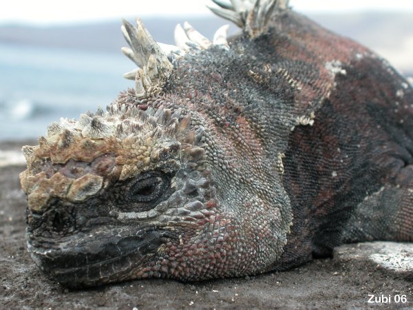
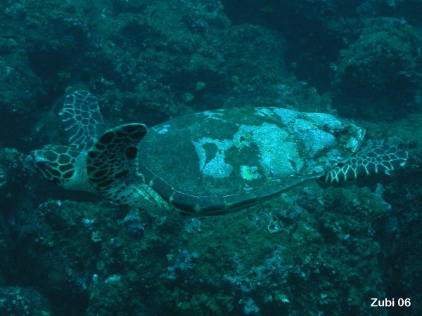
Reptiles:A special animal seen only in the Galapagos islands is the endemic marine iguana (Amblyrhynchus cristatus), which is found on most islands. They represent the only species of truly marine lizards. There are also marine turtles around Galapagos, the green turtle (Chelonia mydas) and the hawksbill turtle (Eretmochelys imbricata). The green turtles here on the Galapagos are unusual dark, probably to better absorb the warmth of the sun in this cold water. The breeding season is during the warmer time of the year. More information: marine iguanas / marine turtles / Photos taken in the Galapagos
|
||||||
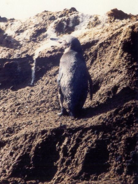
Birds:There are many sea birds living on the Galapagos und while diving or snorkeling you will encounter them sometimes, while they search for food. Of interest for the diver is the endemic Galapagos penguin (Spheniscus mendiculus), the flightless cormorant (Nannopterum harrisi) and the boobies (Sula sp.) which all might be encountered underwater while diving. More information: Galapagos penguin / Boobies / Flightless cormorant / Photos taken in the Galapagos
|
||||||
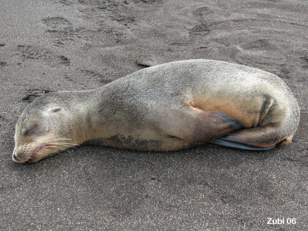
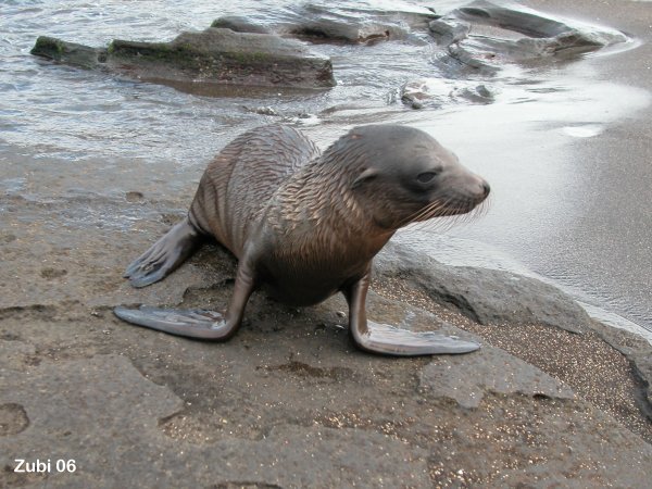
Mammals:On most islands live Galapagos sea lions (Zalophus californianus). They are excellent swimmers and will be encountered often underwater. The endemic Galapagos fur seal (Arctocephalus galapagoensis) are less commonly seen. Whales and Dolphins are encountered when cruising between the islands. A lot of cetacean sightings are at the western side of Isabela, where the water is colder. More information : furs seals and sea lions / whales and dolphins / Photos taken in the Galapagos
|
||||||
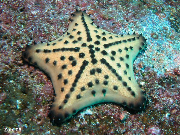
Invertebrates:Corals, sea cucumbers, sea urchins, crabs and shrimps, sponges and anemones live in the water around the Galapagos. There are several endemic species, such as the Galapagos black corals (Antipathes galapagensis), cup corals (Tubastrea tagusensis), 3 species of sea slugs (Onchidella steindachneri, Hypselodoris lapizlazuli and Tambja mullineri) as well as some species of crabs, chitons, scallops and sea stars. More information: largest starfish / Galapagos invertebrates (molluscs, corals, other animals) / Photos taken in the Galapagos
|
||||||
Plants:There are four Mangrove species growing on the shores
of some of the islands and at some lagoons: Black Mangrove (Avicennia
germinans), Red Mangrove (Rhizophora mangle), Button Mangrove or Buttonwood
(Conocarpus erecta) and White Mangrove (Laguncularia racemosa). Mangroves
provide a nesting ground for many fish species.
|
||||||
Recommended book: Take along on your diving trip: |
![]()
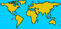
 The
Galapagos Archipelago is truly oceanic with the mainland 960km away. The Galapagos
platform lies 914m below sea level and is surrounded by seas, that average over
3000m.
The
Galapagos Archipelago is truly oceanic with the mainland 960km away. The Galapagos
platform lies 914m below sea level and is surrounded by seas, that average over
3000m.
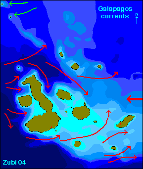
The Galapagos lies in the confluence of 3 major currents. The cold Cromwell current (from the west), the warm Panama current (from the northeast) and the cold Humboldt current from the southeast all influence the climate on Galapagos (map of ocean currents in the Galapagos after Houvenaghel 1978 - red=cold - green=warm water - print version)
The Cromwell current (also called Pacific Equatorial Undercurrent) is a bottom flowing cold current, more like a submarine river, that brings nitrates and phosphates to the islands. This results in major areas of upwellings of cold water to the west of Isabela and to the southwest of San Cristobal, Floreana, Española as well as the north of Santiago. (See Galapagos information)
The Humboldt current moves north along the Peruvian coast and turns to the west just about at the Peruvian - Ecuadorian border. This current originates near the Antarctic and is about 7 to 8° C colder than the ocean normally would be and carries very nutrient-rich water. This current meets the warm tropical Panama current at a point north of the Galapagos Archipelago. This results in the northern islands of Wolf and Darwin having notable warmer water. The cold Humboldt current is predominant mostly from July to December and brings overcast and misty weather with a foglike rain called garúa.
El Niño (Southern Oscillation) is a disruption of the ocean-atmosphere system in the tropical Pacific and has consequences for weather and climate around the globe. During an El Niño the Humboldt current gets replaced by warm water, which is less nutrient rich. There is unusual heavy raining in the normally dry coastal areas of Peru. Major El Niño events occur about every 8 to 11 years. When an El Niño event occurs, it often lasts from 12 to 18 months.
During an El Niño event those fishes that love cold water will move away entirely or migrate from the warm surface to colder water underneath. The food webs depending on the otherwise abundant supply of fishes collapse. In an El Niño year many animals on Galapagos like birds, lizards and sea lions will starve and die. On the other side the increased rainfall associated with the El Niño event will make the otherwise desert like vegetation suddenly grow. Unfortunately also a lot of introduced plant species will prosper, when there is more rainfall.
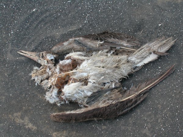
I have visited the Galapagos during the disastrous El Niño event in 1983 where many animals died and again later and I noticed a large difference. Many birds didn't manage to breed, because there was not enough food for their chicks. Penguins were suffering a lot, because they couldn't move to other places. We saw bones of sea lions on the beach and there were less pups than usual. Underwater I saw some bleached corals (I was only snorkeling then). Photos of dead bobbys.

Links: On the effect of El Niño (Galapagos - global) - NOAA Information about El Niño - El Niño years - Pictures 1997 until recent (NASA) - El Niño year 1998 in the Galapagos - Galapagos Oceanography and Climate - Weather Averages in the Galapagos
The Galapagos National Park was established in 1936 and ratified in 1959, the final boundaries were established in 1968. Now 96% of the land area of the archipelago is included in the park. The Galapagos Islands are a UNESCO World Heritage Site. Look at the Galapagos nature calendar for more information about life on land. List of threatened species of the Galapagos / list of species seen in the Galapagos / Endemic fishes and marine animals in the Galapagos


The Galapagos Marine Resources Reserve (GMRR), with waters totaling 140,000 square kilometres, was signed into law in 1986, and now includes all waters within 40 nautical miles offshore. This was upgraded to a Biological Reserve of Marine Resources in December 1996 and in 1998 the Ecuador government expanded the no-fishing zone around the islands from 15 to 40 nautical miles. The Marine Reserve is designed to protect the waters surrounding the Galapagos Islands and the resources they contain. 5% of the entrance fee you pay is used for the Marine Reserve.
Unfortunately the population on the Galapagos has increased a lot in the last 20 years. Nowadays about 30'000 people are living on the 3 islands where they are allowed to live (St. Cruz, San Christobal, Isabela). Between 70,000 and 80,000 tourists visit the Galapagos each year. They have to be provided with food, water and transportation around the islands. This creates a lot of pressure on the environment of these islands and has some negative impact on the animals living here. The park authorities try to minimize this impact, for example all tourists are supervised by a licensed guide when visiting the islands or diving. But there are still problems with illegal fishing (fishes, shark fins, sea cucumbers) and introduced species. More about conservation issues.
In 2007 the Ecadorian President proclaimed the ecosystem of the Galapagos isalnds "at risk and a national priority" but he did not detail the measures. Hopefully he will start some programs to stop the rapid increase in the human population and the gradual introduction of external species of flora and fauna which are threatening the ecosystem on the islands.
![]()
![]()
. Copyright Teresa Zubi