![]()
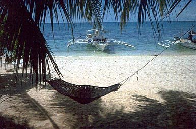
Around Cebu in the Philippines are some very nice places for scuba diving. My favorite is Malapascua, where I saw several thresher sharks, a very special experience, and dived on some interesting wrecks. Another good dive area is in Moalboal, sharks a plenty around Pescador island (go early in the morning) and special critters at the other dive sites.
![]()
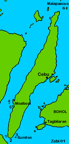
Map of dive areas in Cebu6. Malapascua |
 |
![]()
1. Wall of Death: This dive site lies at the southern point of
the large island of Cebu. It is one of several in this area all along a steep
wall (Wall I and II, Lilly's hideaway), combined with dives in flatter water
(Canyon reef, 17m reef). Because of the current this dive is only for experienced
divers. Hard and soft corals, sponges, many nudibranchs. With luck you find
frogfish (we found a black one with orange
warts!), ribbon eels, some scorpionfish, lionfish and cuttlefish.
Mantas and whalesharks in March to June.
![]()
2. Lilolan and Looc: slopes down to 25m, then sand. Large coralheads, soft
corals, rays, sandeels. There might be some fisherman that are working in this
area.
![]()
Read this text about the Sumilon and Apo Marine Sanctuaries
3. Sumilon island: this is a marine sanctuary. Slope to 35m, then sand. Hard corals, many coralfish. Small caverns, sometimes sharks. On full moon and new moon there are strong currents.
![]()
4. Pescador Island: this is a marine sanctuary. Steep wall with a
cave (Cathedral). Large sponges, soft corals, black corals, gorgonians. Good
place to see sharks, if you go on a early morning dive.
![]()
5. Sunken Island: this is a underwater plateau that starts at 24m
and slopes down to 40m. Large schools of jacks or other big fish, sometimes
sharks and big tunas. Current often strong.
Close to Pescador island are several other divesites.
![]()
Malapascua island lies at the northern tip of Cebu and west
of Leyte. It takes about 3 hours by car from Cebu city to reach the island.
For a map of the dive sites click
here.
![]()
6. Malapascua Island: there is a small Japanese landing
craft in the northwest of the island. The beautiful Mandarin (dragonets) fish
lives in the small reef around it. Visit this dive site around 4 or 5 o'clock
in the late afternoon. That is the time these fish forage for food and are more
easily seen. A special sight is the mating dance, when the Mandarin fish emerge
from their hiding places and form pairs (see report about Lembeh).
![]()
Ship wrecks: there are 5 shipwrecks around Malapascua
island. Some are quite far away so the dive operators Center only go there if
there are enough divers interested.
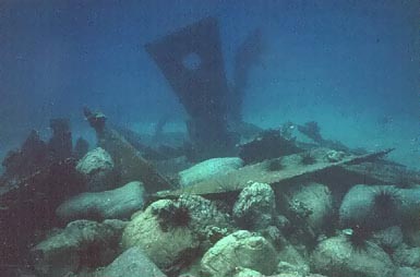
The "Pioneer" is a Japanese warship which was sunk in 1944 and lies now close to Malapascua in 42-51m depth covered with black coral bushes. Schools of glasfish swim through the wreck and huge skorpionfishes lie everywhere. The wreck is very nicely preserved, you can see the propeller and where the large maschineguns were. This is always a deco dive (stops on 6 and 3 meter!) and only for very experienced divers, since there is sometimes a strong current!
The "Dona Marilyn" (1 hour or more by boat from Malapascua) is a 90m ferry which sunk in a typhoon in 1982. She lies between 18 and 30m on her side. She is nicely covered with mussels and black coral bushes. A large fishernet hangs over parts of the ship. Look out for the flatworms and nudibranchs - very nice!
The nameless Japanese cargo wreck (40 min. by boat) lies from 18m to 27m deep. She was very badly hit, a real wreck! Covered with corals and bushes of black corals (actually greenish to yellow when alive) I liked her a lot. Some parts of it look like the ruins of a temple with pillars, all covered with corals.
For more wreck diving check out this travelog about Sangat (Busuanga, Palawan)
![]()
Gato Island: this island lies northwest of Malapascua,
40 min by boat. It is a marine sanctuary. Large boulders lie around the island
and whitetip reef sharks are sleeping underneath. There are also many bamboosharks
under the smaller rocks. There is a large tunnel that crosses the island and
where you can dive through. Also spectacular for night
dives, but watch out for the current.
![]()
Shark point: this dive site lies south of Malapascua.
This is a underwater plateau, 20m deep at the top with walls going down to 60m.
A great place to see thresher sharks (Deutsch: Fuchshai oder Drescherhai) and
sometimes silvertips and manta rays. We dived very early in the morning when
the thresher sharks come up from deeper parts and swim around in circles around
the plateau. I was lucky, when I swam to the edge to look down, a huge thresher
shark came out from the dark, looked at me and lazily swished his long tail
and then was gone again. Since you are diving quite a long time on 20m, watch
your computer for deco!
![]()
Calangaman Island: this island lies southeast of
Malapascua and close to Leyte. There are 3 dive sites around the island, mostly
drop-offs with large schools of fish.
![]()
|
|
|
1. Malapascua / 2. Pescador island / 3. Sumilon island / 4. Sibulan / 5. Dauin / 6. Apo / 7. Sipalay / 8. Cabilao / 9. Panglao (Alona) / 10. Anda / 11. Padre Burgos / 12. Limasawa / 13. Liolan, Sogot Bay / 14. Siquijor |
![]()
Information |
Dive sites around the Daymaniyat Islands, Kharabah, Fahal in Oman (maps, descriptions) - print version |
Photos |
Information |
Galapagos islands: center Galapagos, north Galapagos, southeast Galapagos, west Galapagos |
| Photos |
| Tauchplätze | Indonesien allgemein - Bali - Bali Nord - Bali Ost - Bali Süd - Bunaken - Bangka - Manado- Lembeh |
| Informations-Seiten | |
| Druckversion Karten | Indonesien (Strömungen und Wallace Linie) - Klima-Karte Indonesien - Bali Tauchplätze - Lembeh Tauchplätze - Bunaken und Manado Tauchplätze - Karte der Tauchplätze in den Galapagos - Druckversion |
| Druckversion Texte | Indonesien allgemein - Bali Nord - Bali Ost - Bali Süd - Bunaken - Bangka - Manado - Lembeh |
| Spezielle Themen | Grundsätze zur Berichterstattung über Tauchgebiete |
I have visited all dive sites on this page except Sipalay, Sogot Bay
and Anda. I added some more information in 2003 after my seventh trip
to this area.
. Copyright Teresa Zubi (write to
me)
