![]()
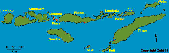
The water around the Komodo and Rinca island is speckled with small islands ringed with beautiful coral reefs. It is also swept by fierce currents which makes for some challenging diving but also for encounters with big fish like sharks, rays and tunas. The Komodo and Rinca islands are the largest of about 80 islands that lie between the islands of Sumbawa to the west and Flores in the east. Together with the extensive area of the surrounding ocean they form the Komodo National Park. Established in 1980, the park was declared a Man and Biosphere Reserve and a World Heritage Site in 1986. The park is most famous for its enormous lizards, the Komodo dragon (Varanus komodensis), the biggest reptile inhabiting the world today, but unfortunately endangered. But these islands also offer incredible riches underwater!
|
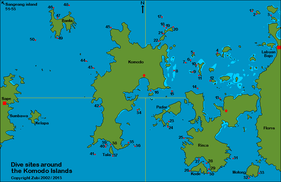
Northeast of the National Komodo Park (= Central area for day trips from Labuan Bajo) - see text and map 1. Sabolon kecil - 2. Sabolon besar - 3. Seraya kecil - 4. Sebayur - 5. Tatawa besar - 6. Tatawa kechil - 7. Current City (Batu Bolong) - 8. Karang Makassar (Manta Point) - 9. Mawan - 10. Siaba kecil - 11. Siaba besar - 12. Pengah (Tengah) - 13. Wainilu - 14. One-Tree (Chinese mound) - 15. Batu Tiga (three rocks) - 16. Pink Beach (Pantai Mera) - 17. Toko-Toko - 18. Castle rock (Batu Toko-Toko) - 19. Cristal rock (Batu Gili Lawa Laut) - 20. Lighthouse - 21. Cauldron Passage (Gili Lawa Laut Passage) - 22. Golden Passage (Gili Lawa Darat Passage) Southeast of the National Komodo Park (=Southern Rinca, Padar, Kode, Montong) - see text and map 23. Pillarsteen - 24. Three sisters - 25. Swallow Hole - 26. Jimmys Rock - 27. Torpedo Point - 28. Cannibal rock - 29. Yellow Wall (Overhang) - 30. Crynoid Canyon - 31. Toro Sie - 32. Apple orchard - 33. Kerita Tol Southwest of the National Komodo Park (= South Komodo island) - see text and map 34. Pulau Indihiiang - 35. Tanjung Lelok Sera - 36. Batu Gaja - 37. The End of the world - 38. German Flag (Toro Bendera) - 39. Manta Alley (Manata Point) - 40. Twins - 41. Langkoi Rock - 42. Broken Hill Northwest of the National Komodo Park (= North Komodo island) and Banta - see text and map 43. Tukoh Serikaya - 44. Wizards Hut - 45. Toro Moncong - 46. Tondok Rasa (Roller coaster) - 48. GPS-Point - 49. Galley rock (Ghally's rock) - 50. Batu Baso Sangean island - not on map, see text 51. Black Forest (Hot Rocks) - 52. Tanjung Menjangan (Lighthouse Bay - 53. Bantoh |
![]()
You can find detailed information about dive operators, liveaboard operators, dive safety, dive conditions, climate, hotels and how to get to the Komodo islands on a separate page ready to print. Print version (PDF) of this page including main map.
![]()
The Komodo islands have become more widely known and there is a teeming dive industry in Labuan Bajo (Flores) with quite a number of liveaboards and several dive operators based there. This dive area is one of my favorite places in Indonesia and I have come back nearly every year to do liveaboard trips or day trips around the islands. There is everything, a diver's heart wishes for, from large sharks, manta rays and tunas to colorful nudibranchs, special shrimps, frogfishes and also just the incredible colorful reefs. The reefs are all in pristine conditions, specially the area that belongs to the national park.
Most of these dives are not for beginners and computers and safety sausage are a must! There are often very strong and unpredictable currents and undertows, sometimes waves and surge and cold water often wells up to the shallow areas, resulting in low water temperatures (often 28 to 29, but sometimes 23 degrees or less, especially in the south). The visibility is quite good. The daily conditions such as tides and currents have to be taken in consideration when planning a dive and sometimes a change of plan might be required. On those occasions don't dispute the opinion of your dive guide or your skipper, they know this place better than you do! Follow your guide underwater, he knows best where to turn back from the fierce currents and take shelter and never dive without a local guide! If everything works out, this is diving of all the superlatives, but the dive can be a wild ride!
Please read about the relatively difficult conditions in the Komodo islands and prepare accordingly - click here.


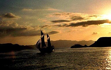
Sailing - Labuan Bajo - Komodo islands
Click on the numbers to go to a description of that dive site. Print version (PDF) diving in the northeast including map.
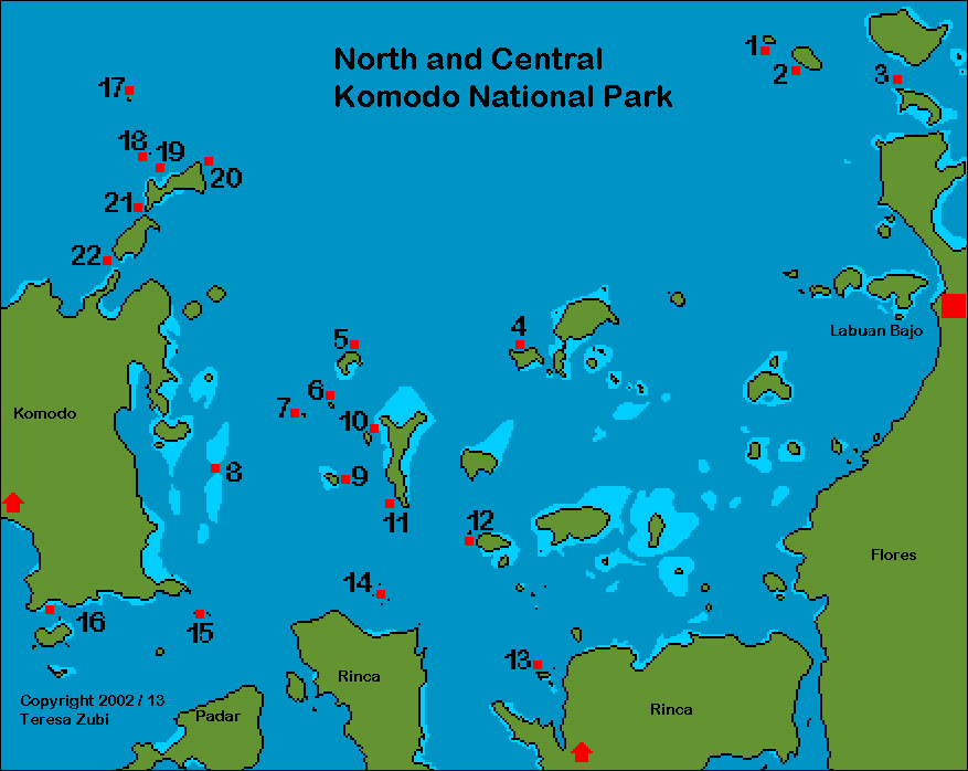
North of Labuan Bajo but outside of the Komodo National Park are three islands which are also good diving and snorkelling spots. This whole area is easily reached on day trips starting from Labuan Bajo.
1. Sabolon kecil: This is a great dive site where you swim out to a seamount which tops at about 22 meters. While crossing the sand area between the slope and the sea mount look out for barracudas, large groups of batfishes and sharks. On the sand there is a colony of garden eels and the seamount is very nicely covered with sea fans and corals. On this site I always want to stay longer on the sea mount, but my dive computer tells me to swim back over to the main reef slope... Nice area with corals on top to make your safety stop.
![]()
2. Sabolon besar: This dive site is mainly used for check-out dives and refresher courses on the sandy area in the southeast. If you like macro you can also hunt around for small critters on the sand and in the coral reef nearby.
![]()
3. Seraya kecil: This island lies only about 8 kilometres from Labuan Bajo and is a popular snorkelling spot. The dive site is quite nice, especially if you go to the small seamount on 30m which lies in the channel. You can also spend the whole dive in shallow water among the corals.
In the center of the Komodo National Park is a group of very nice dive sites, two islands (Tatawa kechil and Tatawa besar), the sea mount Batu Bolong (Current City) and Karang Makassar (Manta point). They lie about an hour to an hour and a half by boat from Labuan Bajo so they are easily reached by day boats.
4. Sebayur: This dive site is a very good place to start getting used to the diving conditions in the Komodo National Park, because you can start on a gentle slope and then continue to a ridge where there is more current. Since I like small critters I also sometimes only dive on the slope and sandy area (15 to 17m) where there are several coral blocks with cleaner shrimps, leaffish, bubble coral shrimps, anemones with porcelain crabs and in the sandy area jawfish and sand eels. Schools of fusiliers often sweep by and groups of bumphead parrotfishes visit the area. Nearly always there are one or two cuttlefishes on the reef, laying eggs into the staghorn corals. This reef area continues towards a long underwater ridge, the sand continues, but deeper and the slope becomes a miniwall with lots of crannies. When the ridge ends there is often some current, large schools of redtooth triggerfishes gather and jacks come by hunting.
![]()
5. Tatawa besar:This is the larger island of the two (besar = big / kechil = small). The best way to dive is to drift with the current along the northeastern side and end up on the corner for the safety stop. You can tell from the coral cover that there can be quite a lot of current here, everything is hugging the ground. Look to the deep, there are always large groupers and sweetlips, often sharks and groups of jacks. Towards the corner the coral get bigger and lots of angelfishes, butterflyfishes flit around. Groups of batfish and sweetlips gather to get cleaned and sometimes you see a turtle or a group of bumphead parrot fishes.
![]()
6. Tatawa kechil: This is a small rocky island lying in a north-south direction so there is always some currents on the longer sides of the island. There are a series of very large boulders and rocks to the west, all covered with Orange Cup Corals (Tubastrea coccinea). Then from about 17 to 20 meters a slope begins. Among the boulders a lot of fish gather, some hidden in between or under the huge boulders, batfishes, snappers, sweetlips, the shy barramundi cod, morey eels and sharks. Over the slope huge groups of grey snappers (Macolor niger) and humpback snappers (Lutjanus gibbus) gather and jacks, trevallies and tunas hunt here. A great dive site, but mostly it is dived in slack tide and even then you might have to change directions because of the currents against you. On the top there is some recent damage, probably from dynamite fishing which is forbidden in Indonesia.

Toro Moncong - Current City
7. Current City (Batu Bolong): This is a large sea mount with only a few rocks emerging above the surface. You always dive in the current shadow, so depending on the current you dive either the northern or southern side while the other side is inaccessible. If the currents are strong the area where you can dive gets smaller and smaller since the water presses in from the east and west. Look up to the surface and you will see the disturbance of the current, whirls and eddies forming two bands like rivers to the right and left of the rock.
On this dive site it is very important to turn back when your dive guide does and swim relatively close to the ground. On one of my dives one of our group overtook the dive guide, got too close to the edge and got suck down from 27 to 48 meter while going head over heels in the whirl. He lost one fin and the other was ripped badly at the strap. His BCD was nearly lifted off his body (!) by the current and he surfaced out in the blue. There was no way we could (or wanted!) to follow him, we lost sight of him immediately. Only on very rare occasions when the slack tide is very pronounced (when the tide turns and there no appreciable tidal current flows) you can swim all the way around the rock - actually in the many dives I have done here I have done it twice! MORE ABOUT CURRENTS
The North side: This side of Batu Bolong is wider than the southern part. On the eastern side there are several steep rocks jutting nearly to the surface with canyons between. This area can only be reached during slack tide, most times you have to turn back before you can see all the rocks, because fierce currents start to tug at you. On the western side there is a long slope, but again there is a point where you have to turn back because the currents are too strong. Between lies a fantastic reef area with thousands of fish schooling around you – damsel fishes, surgeon fishes, redtooth trigger fishes and anthias. In the current swept areas on both sides you often see mackerels, trevallies, large tunas and rainbow runners. White tip reef sharks and Napoleon wrasses are seen in the deeper areas and there is always a large group of sweetlips getting cleaned on the upper east side.
The South side: This area is smaller than the north side and with currents pressing in from both sides and several dive groups it sometimes can get a bit crowded. I always see several large turtles here, resting in the deeper parts and occasionally swimming up to the surface for air. The upper part here is especially nice with large clouds of damselfish, colorful angelfishes and anthias and hunting jacks and trevallies.
![]()
8. Karang Makassar (Manta Point): Karang means “reef” in Bahasa Indonesia, but actually this is more like a long area of gravel and broken coral pieces with small coral blocks. You dive with the current, preferably from north to south, so you end up in the nice coral reef lying in the south. This is not a deep dive, just about 15 to 17m, but the loose gravel makes it difficult to stop anywhere for longer. I prefer to dive here rather a bit overweighed, so I easily go to ground if I see a manta. So basically you just go with the current and look out for manta rays, either close to some of the coral blocks (getting cleaned) or up at the surface (feeding).Of course there are also other animals living here – sharks, eagle rays, large thorny ray (Urogymnus asperrimus), but also small fish like special dartfishes, gobies, flasher wrasses and morey eels.
![]()
9. Mawan: This dive site is good for a second or third dive, because the good stuff is found between 15 and 3 meters. It is amazing how diverse coral cover can be in a small area. First you dive on very ground hugging corals and leaflike sponges, obviously an area where there is often a strong current. Then you continue to an area of mixed corals and white sand, five minutes later it changes to an area covered entirely with a certain type of bubble corals (Euphyllia sp.) and soft corals. Then a beautiful reef starts with anemones and anemones fishes everywhere.
![]()
10. Siaba kecil: This dive sites usually has a lot of strong current, since it lies in a channel between two islands. You best dive north to south in a fast drift dive, starting on a steep slope with ridges, funnels and channels. Everything seems to be smoothed down by the currents, coral cover is low and gravel shows between. To slow down you shelter in the overhangs and behind the outcrops – look out, sometimes there are also sharks hiding here. Beautiful sea fans grow under the overhangs, but usually you don’t have time to linger, because the current sweeps you on. I remember several dives where I couldn’t shoot a single photo, because the ride was so wild, but once I actually had no current at all and had to fin the whole distance – a new experience! Once you reach the corner where there is a field with gravel and sand the coral cover changes, there are larger blocks and sponges. You finish the dive on a huge field of staghorn corals. Every time I dived here I saw at least one turtle, sometimes more. Approach them slowly and you might see how they feed on sponges, when they do that they are not shy at all and don’t flee from the divers.
![]()
11. Siaba besar: You start the dive in the north and drift along beautiful corals, gorgonian sea fans, black coral bushes and sponges. The dive ends in a coral garden where you can also find Mandarin fishes (Synchiropus splendidus). They live under and in between the branches of staghorn corals and during the day they are very well hidden. But around 5 o'clock (dusk) they start to forage among the corals and it is more easy to find them. When it gets darker you might also see their courtship dance where the male (larger) displays his dorsal fins to attract the female. Then they rise together from their lair, side by side, and head for open water to release spawn and eggs.
![]()
12. Pengah (Tengah): This rocky island lies north of Rinca island, relatively close to the narrow bay leading to the ranger station there. Underwater one corner of the island has a plateau covered with hard corals, the other corner is a steep wall with rocks jutting out. Depending on the current you either dive the northern or southern side. The wall with the rocks is really very colorful, with sea fans, special blue tunicates and covered with many feather stars. Actually this type of covering is similar to what you find more south where the water temperatures are lower. The current here can be very strong at times and you are lucky if you can round the corner and don’t have to turn back. The plateau has nice staghorn corals and table corals and sometimes large groups of bumphead parrotfishes.
![]()
13. Wainilu: On my fifth trip to the Komodos I didn't feel like going on land to see the Komodo dragons at the Rinca Park station, so I went diving in Wainilu. First it didn't look very promising - lots of dead corals, sand and rubble and low visibility, but then we started to discover things - nudibranchs, some of them only a centimeter long, three types of mantis shrimps, banded pipefishes and to top it off several Mandarin dragonets hiding under the large black sea urchins! So this is more like a muck dive where you take your time, look under corals and among the rubble and discover hidden critters.
![]()
14. One–Tree (Chinese mound) lies in the north of Rinca and the coral cover is similar to other northern dive sites. This is a small island with one mangrove tree growing on top. You dive on a slope with overhangs and small caves and bowls. We saw up to seven Napoleon wrasses together and also two sharks. There were a lot of angelfishes around and under the overhangs were several of their colorful juveniles.
![]()
15. Batu Tiga (three rocks) lies in the Linta strait and the currents can be quite fierce, so it is not always possible to dive here. This is a very nice dive on three underwater rocks and terraces. Several Napoleon wrasses accompanied us on our dive. We saw three blacktip reef sharks and really large groupers as well as bumphead parrotfishes.


View from the park - Komodo dragon
16. Pink beach (Pantai Mera):This dive sites lies very close to the Komodo ranger station and many boats come here for snorkelling because the beach has a special pink color from red coral fragments mixed with white sand. It is a slope with a sandy bottom. The water temperature is already lower, sometimes down to 25 degrees and you also find some of the animals which normally live in the south like the small yellow sea cucumbers and lots of feather stars. Look around the rocks and under the corals, there are frogfishes and leaffishes and several cleaning stations. A nice dive to do after you have visited the dragons or for a night dive, especially since you can find Mandarin fishes in the shallow part.
The dive site on north Komodo and Banta are some of the best, but also really not for beginners! The currents here are very strong and unpredictable, because the Indonesian throughflow hits the islands straight on from the North, then either sweeps east and west along the islands or falls (downcurrent) or rises (upcurrent). Depending on the tides the current also shifts and comes from the South, but generally less strong.
Dives have to be planned, so you hit a certain dive sites on rising tide, falling tide or slack tide. This makes for shifting currents and eddies but also attracts large fish in quantity! The procedure how to dive here (and some Banta dive sites) is as follows – these are underwater mounds and rocks just barely reaching the surface, so the important thing is to hit the rock when you descend and not get swept by with the currents and miss it. Sometimes you even have to hit the rock exactly at a certain more sheltered place to dive a certain dive profile! The trick is to jump upcurrent from the rock, jump in fast and as a group, then submerge immediately so the surface currents can’t sweep you away, then descend as fast as you can until you reach the rock, so the current doesn’t sweep you past, then stay put until the whole group gathers. Then you might have to swim for part of the dive against the current so you can reach a particular area or you might hit eddies and whirls where the current hits and rebounds from the sides of the rock. To surface you have to swim out from the shelter and might hit down currents, so always start to surface when you still have enough air and that’s 70bars and not 50!! That is why these dive sites are not for beginners!!! MORE ABOUT CURRENTS
17. Toko-Toko: This is a small rocky island which lies just outside of the Komodo National Park, although close to Gili Lawa Laut. Lying exposed fully to the Indonesian Throughflow coming from the north, currents are usually very strong and also bring a lot of pelagic fish, but there is also a large plateau with nice table corals and hard corals. (2013 –I heard part of the plateau is damaged)
![]()
18. Castle rock (Batu Toko-Toko): This is an underwater mount (top 6-7m) and one of the best places is a long flat plateau on 20m which then starts to slope down. There are several large coral blocks and there you just stay (preferably with the current coming against you and with a reef hook ready) and wait for the sharks. We had at a time from 10 to 20 white tip reef sharks and a few greys cruising by, jacks, trevallies and dog tooth tuna among them, then a huge school of blue-black fusiliers – just great!! If the sharks are not here, they are also sometimes on one or the other side, but then more scattered and swimming in the blue water. You can also see Napoleon wrasses, midnight snappers and sometimes barracudas. There is a hollow at about 15m where sometimes huge schools of mackerels, doctor fishes and jacks are gathering, rising in a long band, forming whirls and walls. Just beautiful! At this place you might even see dolphins underwater, if you are very lucky. To make your safety stop you go back to the main pyramid shaped rock where depending on the direction of the current you hide in the current shadow and then surface (with enough air - 70bars - downcurrents possible!) from there.
![]()
19. Cristal rock (Batu Gili Lawa Laut): This is a rock that is submerged at high tide. The trick is to stay at a place where there is some current so you can see big fish, but not so much current, that you must hold on for dear life. On one side of the rock there is a small plateau where you can easily descend and ascend with broken corals (used to be a nice area with staghorn corals and table corals), only that is not always accessible due to the currents. Further down (ca. 15 to 22m) there is a small valley with several huge coral blocks, where a large group of yellow Oriental sweetlips and a pair of barramundi cods reside. If there is a lot of current this is the place for jacks and trevallies and large schools of fusiliers and sometimes sharks! On one of our dives an eagle ray stayed with us very close, then lazily flickered the fins just a bit and was off into the blue. We saw Napoleon wrasses, large groupers and mackerels and we even saw a few pygmy seahorses living on Muricella sea fans - they were also holding on with their tiny tails because of the current!
![]()
20. Lighthouse: On the northeastern point of Gili Lawa Laut, just below the lighthouse lies a nice protected area for diving, a gentle slope covered with beautiful blocks of table corals and other hard corals mixed with black coral bushes and soft coral and white sand. Here on the sand or under the large table corals there are several sharks sleeping, approach them slowly and they will stay put for a good look. A great dive site for a third, shallower dive.
![]()
21. Cauldron Passage (Gili Lawa Laut Passage): There are two narrow passages cut through the Lawa Laut islands and especially the Cauldron Passage in the north should only be dived by divers who know how to manage currents, because they sweep you through at a very fast pace and once you have started the dive you can’t stop! There is a part where you have to go from about 25 meters up to 14 meters with your dive computer going crazy and then down again to about 22 meters into a large sand bowl – the cauldron. Most times you can then go along the right edge where there are some nice coral formations, but sometimes you have to cross the sand depression and go to the left. This can be very difficult because on some stretches you might be swimming against the current and there is nothing you can hold on to in the sand. On left side there are some canyons and you finish the dive on a nice coral reef. This dive site can also be dived during slack tide and in reverse direction and then is not such a wild ride.
![]()
22. Golden Passage (Gili Lawa Darat Passage): Diving through this passage is a bit less wild, more like a fast drift dive but you have to be careful not to get too close to the southern edge where the currents can sweep you down and out. The ground here is covered with gravel and small reef patches. A good place for barracudas, also sometimes mantas and eagle rays. If you dive west to east you end up in a very nice coral area with schools of fish, jacks and trevallies and coral boulders covered with glass fish.
![]()
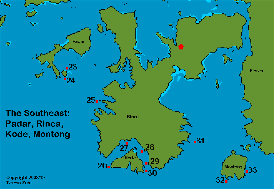
Click on the numbers to go to a description of that dive site.Print version (PDF) diving in the southeast including map.
If possible try to spend some time in the south of the Komodo National Park. The water usually is much colder (21° to 26°C) than in the north and visibility poorer, but I just love it here for there are so many unusual critters you find. South of Pulau Damar there is a marked change in what kind of animals you see. There are filterfeeders like feather stars and sea cucumbers everywhere and soft corals and sea fans in incredible orange, purples and yellows grow on every surface. The abundance of life is just amazing! Diving in the south is best during the northwest monsoon, October to April. Some dive sites can be inaccessible because the seas are too rough. Visibility is sometimes not so good (10-15m) because the water is very rich in plankton.
23. Pillarsteen:This dive site lies on the southeast of Padar island. A tremendous dive site where the underwater topography includes huge bolders and rocks with nice cuts, swimthroughs, chimneys and canyons. There are some caves at about 40 and 16meter. Everything is beautifully covered with colorful soft corals, gorgonians, hydroids, sponges and also the sea apple (see No. 32). This was one of the nicest dive in this area but we sure had to swim a lot against the current (on another dive here it was much easier, it just depends on tides and currents)!
![]()
24. Three sisters: These are three large rocks connected to each other with ridges, nicely covered with corals and just teeming with life. Around 30m are two smaller boulders that are especially nice. We saw several species of nudibranchs, small sea cucumbers and a special starfish. You dive in the shade of the current and finish the dive on the peaks which top at 6, 7 and 8 meters respectively.
![]()
25. Swallow Hole lies to the way south to the Horseshoe Bay on the southwest side of Rinca. There is a small island with a large cave where swallows live. If conditions are right you can enter the cave through one of three entrances. For diving you go to a pinnacle some distance offshore from the island where you dive around the pinnacle, on a ridge and in the channel. Everything is covered in beautiful corals and colourful tunicates and sponges.


Coast of Rinca - Horseshoe Bay - Sunset in Padar
I have been several times to the horseshoe bay and we usually anchored just a short distance from the best dive sites. The slopes are all covered with trees and the beach is visited by monkeys, Komodo dragons, pigs, deer and herons. There are several eagle nests on some of the larger trees and you can observe these beautiful birds how they catch fish.
26. Jimmys Rock is a submerged sea mount lying to the southwest of Kode island. The top of the mount is around 8m. A good place for sharks and barracuda and lots of small interesting critters on the slope.
![]()
There are several other dive sites in the horseshoe bay. Batu Mandi Rinca to the west is a slope with large coral blocks covered with lots of hard and soft corals and the ever present feather stars. 27. Torpedo Point looks similar but with more sandy areas between. Both are excellent for nudibranchs and frogfishes - but also look under the coral blocks for nurse sharks and the torpedo rays.
![]()
28. Cannibal rock: This is one of my favorite dive sites in the south. An underwater mound covered with soft corals, sponges and hard corals. On every available surface there are either feather stars, brittle stars, sea cucumbers or sea stars. Both Cannibal rock and the Apple orchard (No. 32) are also literally covered with the colorful filter-feeding sea cucumbers called sea apples (Pseudocolochirus violaceus). This sea cucumber is round and of a bright red and purple color with white or yellow stripes. It holds on to the substrate with tiny feet (it looks like a colorful sponge) and stretches its tentacles into the current for planktonic food. It is rarely seen but here in the southern part of park they are very abundant. Cannibal rock is well worth doing several dives because of the abundance of life here. On every dive we saw several species of rare nudibranchs, special crabs like the Zebra crab, sea urchin shrimps, frogfishes and scorpionfishes. On the reef top there are a lot of anemones with their host anemone fishes, I reckon there are at least 5 different species close to each other. The only disadvantage - the water here is really, really cold!
![]()
29. Yellow Wall (Overhang) and Crynoid Canyon (No. 30) are quite similar - walls covered with feather stars and sea cucumbers - and a short distance out the open ocean lies another excellent dive site, the Pyramid. To some divers feather stars might all look the same, but here you can really observe many different species! The water here is especially cold, since it is upwelling from deep in the ocean south of Rinca. Especially good for nudibranchs (I saw 8 uncommon species on one dive!), special shrimps like Vir philippinensis or the needle shrimp which lives between the spines of the sea urchins. On one dive there I even saw the rare Coleman shrimp on one of the colorful toxic sea urchins.
![]()
31. Torro Sie lies to the southeast of Rinca. It is supposed to be a good place both for macro and also for pelagics. From here it is possible to go north through the Molo Strait to reach Labuan Bajo. This strait is extremely narrow so the currents are very fierce. Last time we used this strait the captain of our liveaboard told me we were making 9 knots - but actually we were only crawling north, because the currents were around 8 knots against us. The narrowness of this strait also makes for dangerous navigation, so some captains prefer the longer but safer way up the west side of Rinca.
32. Apple orchard and 33. Kerita Tol: lie on the southern cost of Gili Motong (also called Gili Mota) in the Molo Strait. They are supposed to be dive sites with very cold water (upwellings) and the visibility is not always very good. Lots of plankton, so from what I heard you often see mantas and sometimes whalesharks here.
![]()
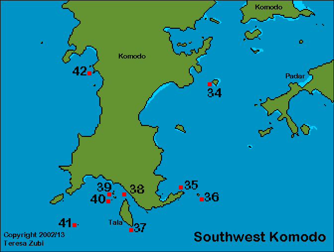
Click on the numbers to go to a description of that dive site. Print version (PDF) diving in the southwest including map.
Again - the water in the south of Komodo usually is much colder (21° to 26°C) than in the north. Diving in the south is best during the northwest monsoon, October to April. Some dive sites can be inaccessible because the seas are too rough. Visibility is sometimes not so good (10-15m) because the water is very rich in plankton.


Tanjung Lelok Sera
34. Pulau Indihiiang: This island lies in the Linta Strait which separates Rinca island from Komodo. The best dive is in the east, a steep slope covered with small corals and sponges. There are some very interesting tunicates (Neptheis sp.) growing here. Instead of covering rocks with their colonies, they form a colony that looks like a grape with a stem. There are often whitetip sharks, jackfish and trevallies.
![]()
35. Tanjung Lelok Sera:This dive site, in the southern part of Komodo close to the open sea towards Sumba, is very nice indeed. Here the water is much colder than in the north. You can dive along the coast towards the eastern edge but the best places are several submerged huge rocks with canyons between them that lie a distance from shore. Currents were very fierce and we had to keep to the lee side of the rocks but fish life is so rich there, Napoleon wrasses, sweetlips, snappers, groupers and a lot more.
At this place one of my worst fears nearly came true – getting lost at sea! We were on the pinnacles and realized, that we couldn’t swim back to the main reef but had to ascend from the top (17m) directly to the surface. Even when we ascended we felt the tug of the currents and the pinnacles rapidly receded from us. When we surfaced we realized, that the three of us were already in the middle of the strait between the mainland of Komodo and a small island, Batu Gaja, and were rapidly pushed out to the open sea south towards Sumba. Actually the boatman was in the process of picking up the other half of our group which hadn't made it to the pinnacles and didn't see us surface. We were swept about a kilometer and a half out and were rescued after a long, long hour - believe me, that’s a long time in cold waves and you get really scared when you can’t see the boat anymore!
![]()
When we came back on the boat we realized, we were picked up close to the dive site with the name of The End of the World (No. 37) which lies close to Tala island. This dive site is a sheer wall of black rock that goes down to about 100meter. Next to it is German Flag (No. 38), also called Toro Bendera, a reef slope with blocks of rock and a lot of whip corals in the deeper areas. This is also a good place for mantas.
![]()
36. Batu Gaja: This is a sharp edged rock formation and the diving takes place in the calmer area between these formations because as soon as you dive too close, the water turbulence such as downcurrents and whirls are just too much. We saw a huge grouper (about 2m), several turtles, rainbow runners and a large group of bumphead parrotfish.
![]()
39. Manta Alley (Manta point): We dived early in the morning and just before the high tide, when there was little current and the light was just beautiful over the coral reef. We stayed in shallow water all the time and just floated a couple of meters below the surface. Immediately the manta rays appeared swimming close to the surface and then swept past us several times. At one point a manta swam directly towards me, did a flip and passed me so close, that I could have touched it. After about half an hour they all disappeared and we continued our dive by looking at all the small stuff you find here also. The reef is beautifully covered and large schools of yellow snappers are everywhere. We also encountered some sharks and turtles and just before we surfaced, a manta came back as if to say goodbye to us!
![]()
40. Twins: The dive site consists of two rocks with a channel between. This dive site is only for experienced divers since there can be strong currents, surge and the water can be quite cold. Lots of large fishes like sharks, mantas, eagle rays, jacks and trevallies.
![]()
41. Langkoi Rock: This is a remote pinnacle to the south of Komodo in the open sea. Its top is about 5m deep with a second smaller pinnacle rising to about 28 meters to the south. Lots of current, swells and down currents but also lots of large pelagics like trevallies, tunas, rays and even hammerhead sharks have been spotted here. Similar to No 18 (Castle rock) but with colder water. MORE ABOUT CURRENTS
![]()
42. Broken Hill: this is a small island on the west side of Komodo island. Mainly visited by liveaboards starting from Sape or coming from southern Komodo. I don’t know this dive site, but it is supposed to be a pinnacle with a nice coral area nearby.
Click on the numbers to go to a description of that dive site. Print version (PDF) diving in the northwest, Banta and Sangeang including map.
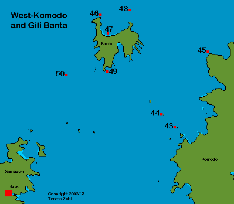
43. Tukoh Serikaya is a small island and 44. Wizards Hut a rocky pinnacle lying to the west of Komodo islands. Both dive sites are very exposed to the currents sweeping through the Sape strait. These dives sites are only reached by liveaboards and even they venture seldom here, mostly on their way to Banta island.
![]()
45. Toro Moncong (Monco): Lying on the most western tip of North Komodo this dive site is visited mainly by liveaboards. You dive on a slope with some larger coral blocks on 25 to 30 meters. There is a very nice miniwall on the upper part with cracks full of colorful glasfishes. The landscape underwater is beautiful with table corals, small sea fans and a lot of small fish and large schools of batfish. A place to relax and look for small animals. I was lucky and found a yellow baby warty frogfish (A. maculatus) only about 5cm large and on another dive a pair of tiny shrimps living in black corals and a rare nudibranch, Notodoris gardineri. The bay Teluk Toro Monco is a good place for a night dive.
Banta is not part of the Komodo National Park but well worth a visit. Some of our best dives during liveaboard trips were around this island in the northwest of Komodo, sitting pat in the entrance to the Sape Straight. Currents are especially strong here because this is one of the widest gaps between islands in Nusa Tenggara, although only 200 to 300m deep. Cold water from the Flores basin in the north is pressed against and up through this gap so temperatures are low but visibility is good. MORE ABOUT CURRENTS
46. Tondok Rasa (Roller coaster): The fierce currents that can develop here give this dive site its name. Actually on one of our dives we startled a shark which was laying in one of the crevices and even he got swept up and down until he managed to get around the corner to calmer waters! I nearly had to laugh to see him struggle! The conditions make for an exhilarating dive. On another dive we had so much upcurrent, that we were swept dangerously fast up from about 18m to 8m and had to finish the dive early out in the blue - there was no way we could have gotten back to the reef. But this dive site is also the place I saw one of the largest group of sharks while diving in the Komodo area. There is an impressive area with large blocks of rock and a deep canyon between them around 45 meter depth. On the way up I had just spotted three large whitetips below me, when a large grey shark appeared in the somewhat murky water (visibility around 15m) and swam directly towards me. Suddenly there loomed another grey just behind him and they started to circle. I had to go up, because my computer showed me decompression approaching fast, when suddenly five whitetips joined the greys. Great!
![]()
47. Tanjung Tondok Rasa: The large bay (Tanjung) between GPS-Point and Tondok Rasa forms a protected area ideal for a night dive. On one dive we so saw so much, we didn't want to leave the water! It started with a small black frogfish perching on a red sponge, then a real stonefish, large nudibranchs and several species of colorful flatworms, crabs and shrimps and to top it off a sleeping shark.
![]()
48. GPS-Point is a submerged sea mound and lies some distance north of Banta in an exposed area. This dive was recommended to us by several fellow divers and it lived up to our expectations! Currents were moderate (but our dive guide said, they can be fierce!) but we saw 8 whitetips, a large school of barracudas, several groups of king mackerels and dogtooth tunas and a large turtle. But even with relatively calm waters it was amazing how just a couple meters over and closer to the reef there were strong whirls and eddies.
Banta Galley rock (Ghally's rock)
49. Galley rock (Ghally's rock): When we arrived by boat we circled around the rock and tried for some fishing. Looking at the surface current it seemed a dangerous place to dive. Everywhere whirls and the water crashing against the jutting rocks. Several times the whole boat was slightly turned by the strong current. Then my dive buddy (an Englishman who actually likes to cook, especially if it is freshly caught fish), who was fishing hooked something so large, that it managed to get off the hook again (there went our dinner - sigh!), we decided this had to be a great dive area. When the current calmed down some time later we jumped in the area just in-between the two arms of current running against and around the rocks. A great dive with sharks, large tunas, yellowfin barracudas and several Wahoos. The dive area is first a gentle slope but then changing to a wall, then around 30m it is relatively flat with large sponges. You can dive both the north and the south side depending on the currents. Actually there is a difference in the type of animals living on each side, similar to the differences observed when diving in the northern or southern part of the Komodo islands. What was not so great here - it was 24° C - f... cold!
![]()
50. Batu Baso: This partly submerged rock lies smack in the middle of the Sape strait, a short distance south of Banta. This strait is a major throughflow for water coming from Sulawesi in the north and flowing to the Indian Ocean in the south. Currents mostly flow north to south and around an obstacle like Bato Baso. From the boat we could see whirls and whorls trailing the rock for hundreds of meter! We dived both sides before and after the change of tides. This is such a great place! On our first dive we saw a marble ray that must have been more than 2 meter in diameter and a huge school of rainbow runners and several Spanish mackerels. On the second dive there were so many sharks (small and middle size, whitetips and greys) that I gave up counting. Deep down, large schools of bannerfish and damselfish were doing a syncopated dance for us.
Sangeang island is formed by the volcano Gunung Api (fire mountain) formed by two peaks Doro Api (1949m) and Doro Mantoi (1795m). This volcano, one of the most active in the Lesser Sunda Islands with the last eruptions in 2012 and 2014 when you could see the ash plume all the way to Labuan Bajo and no flights were possible for several days. The island is about 13 km wide and lies to the northeast of Sumbawa Island. The volcano is large and if the weather is fine it can even be seen from Labuan Bajo, lying to the east towards the sunset. (Information about Sangeang volcano: Smithsonian institute / Sangean volcano seen from space).
51. Black Forest (Hot rocks): This dive site on the north east of the island really makes you realize what it means to dive at an active volcano! There is an area with bubbles rising from warm black sand, the water at some places is really hot (see also Siau dive site). Further down you have a really nice dive area with black coral bushes, gorgonians with hawkfishes and pygmy seahorses living in them. Currents can be a bit tricky.
![]()
52. Tanjung Menjangan (Lighthouse Bay):A sheltered dive site with black sand and a colorful coral garden. A great place for small critters like nudibranchs, shrimps and crabs (even boxercrabs), frogfishes and pipefishes and a place to see the flame file shell which seems to show electric flashes (actually it is light reflecting on thin bands on the mantle of the shell). Really good muck diving!
![]()
53. Bantoh: A small fishing village on the west side
of Sangeang. A good place for a night dive.
![]()
Currents in the Komodo National Park are often very fierce and there are nearly always down currents and large eddies, whirls as well as swells. Why is this so? Geologically, Komodo and Rinca are part of Flores lying on a relatively shallow shelf and are separated from Sumbawa by the Sape Strait where depths are almost 300m. This strait is one of the main channels for the Indonesian Throughflow (as is the Lombok Strait between Bali and Lombok and the Ombai Strait between Alor and Timor), a water movement that starts in the Philippines, flows past Sulawesi on the west and east and then hits the barrier of what is Nusa Tenggara (Lombok, Sumbawa, Flores). From here it finds its way to the Indian Ocean in the south. The Indonesian Throughflow is strongest during the southeast monsoon (June, July, August) which means, that currents can be really strong here, reaching up to 8 knots (1 knot = 1 nautical mile per hour = 1.852 km per hour)! Just to show you how strong this is - while shipping north against the current our ship started to go backwards. Since she normally made a good 8 to 9 knots, the current must have been around 9 knots!
During these months water temperatures are low, 21° to 27° (in the south) and 26° to 29° (in the north), so better bring a 5mm wetsuit with a hood and wear gloves. Otherwise you will learn a new Indonesian word: "Ding ding" (very cold). Actually on our trip with the Gran Komodo liveaboard it was so cold, that one of my dive buddies made a hood out of a plastic bag, so he wouldn't be freezing his ears off! The months of January to February are not so good, there might be some rain. The visibility in the north worsens and the south although warmer than usual can be difficult to reach because there often is a lot of wind.
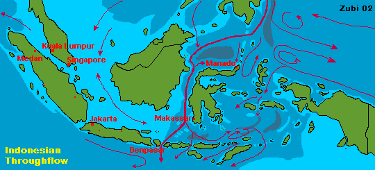
Map of the Indonesian Throughflow (current patterns in February - print version - weather map)
There are some easy dives around the Komodo islands (I recommend 1. Sabolan, 4. Sebayur, 9. Mawan and 13. Wainilu), but most of the interesting diving is done close to rocks or small islands sticking out just a bit during low tide, or on underwater seamounts. Usually you dive on the lee side, where the current is not so strong and where there are some areas where it is safe to ascend at the end of the dive. The other side usually is totally inaccessible due to the fierce currents. Oviously, this kind of diving is only for someone who knows how to handle currents! Computer and gloves are a must because you might have to hang on for dear life. You better have a safety sausage (inflatable signal device) along with you in case you get swept off and away to the open ocean after a dive. Actually in 2008 a whole group of divers was swept south for around 25 miles. After 10 hours in cold water they managed to climb ashore on Rinca island and spent 2 nights there before being rescued! I also had to wait an hour in cold water while being swept out in open sea (see No. 55). Since then I have heard of several incidents, none of them so dramatic, but it shows that you better choose a solid dive operator with a good boat, a vigilant captain and experienced dive guides!

An experienced dive guide will take a good look at the currents and decide where and when to dive. Still, currents are unpredictable and you might end up like me once! At the apply named dive site "Current City" (No. 7) currents had swept in really fast from the side and we were hanging on waiting for a chance to ascend. My mask was wobbling and the regulator was trying to escape sideways from my mouth, the air was sucked straight down and out, forming a cloud of bubbles below us. Finally when reaching only 70 bars and the currents were still very fierce we gave up and let go to ascend to the surface. But we were first sucked down several meter while finning frenetically up, sucking air like crazy, then suddenly swept upwards again (too fast, computers beeping - dumping air like crazy) to end up in 6m but with our air bubbles going up in little tornado shaped whirls and the coral mountain receding fast in the distance! The members of our group were separated and were picked up widely apart, the surface current was so fast. For some more stories read the description of the dive sites....! Want to know more about how to assess accurately the rate of current? Click here.
![]()
Komodo National Park Website / the Komodo dragon hub / Komodo dragon central
![]()
Information |
Dive sites around the Daymaniyat Islands, Kharabah, Fahal in Oman (maps, descriptions) - print version |
Photos |
Information |
Galapagos islands: center Galapagos, north Galapagos, southeast Galapagos, west Galapagos |
| Photos |
| Tauchplätze | Indonesien allgemein - Bali - Bali Nord - Bali Ost - Bali Süd - Bunaken - Bangka - Manado- Lembeh |
| Informations-Seiten | |
| Druckversion Karten | Indonesien (Strömungen und Wallace Linie) - Klima-Karte Indonesien - Bali Tauchplätze - Lembeh Tauchplätze - Bunaken und Manado Tauchplätze - Karte der Tauchplätze in den Galapagos - Druckversion |
| Druckversion Texte | Indonesien allgemein - Bali Nord - Bali Ost - Bali Süd - Bunaken - Bangka - Manado - Lembeh |
| Spezielle Themen | Grundsätze zur Berichterstattung über Tauchgebiete |
. Copyright Teresa Zubi (write to
me)